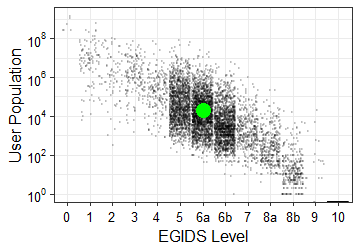
The EGIDS level for Zoque, Francisco León in its primary country is 6a (Vigorous) — The language is used for face-to-face communication by all generations and the situation is sustainable.
This graph shows the place of Zoque, Francisco León within the cloud of all living languages. Each language in the world is represented by a small dot that is placed on the grid in relation to its user population (in the vertical axis) and its level of development or endangerment (in the horizontal axis), with the largest and strongest languages in the upper left and the smallest and weakest languages (down to extinction) in the lower right. The population value is the estimated number of all users (including both first and second language speakers); it is plotted on a
logarithmic scale (where 100 = 1; 102 = 100; 104 = 10,000; 106 = 1,000,000; 108 = 100,000,000). The value for the development versus endangerment dimension is the estimated level on the EGIDS scale. (See the pages on Development and Endangerment for a fuller explanation.)
Zoque, Francisco León is represented by a large, colored dot. When the population is unknown, a color-coded question mark appears at the bottom of the grid. When there are no known users, an X appears at the bottom of the grid. The color coding matches the color scheme used in the summary profile graphs on the navigation maps for the site. In this scheme, the EGIDS levels are grouped as follows:
- Purple = Institutional (EGIDS 0-4) — The language has been developed to the point that it is used and sustained by institutions beyond the home and community.
- Blue = Developing (EGIDS 5) — The language is in vigorous use, with literature in a standardized form being used by some though this is not yet widespread or sustainable.
- Green = Vigorous (EGIDS 6a) — The language is unstandardized and in vigorous use among all generations.
- Yellow = In trouble (EGIDS 6b-7) — Intergenerational transmission is in the process of being broken, but the child-bearing generation can still use the language so it is possible that revitalization efforts could restore transmission of the language in the home.
- Red = Dying (EGIDS 8a-9) — The only fluent users (if any) are older than child-bearing age, so it is too late to restore natural intergenerational transmission through the home; a mechanism outside the home would need to be developed.
- Black = Extinct (EGIDS 10) — The language has fallen completely out of use and no one retains a sense of ethnic identity associated with the language.
The EGIDS level indicated by the large, colored dot may be higher than the EGIDS level reported in the main entry for the language. This is because a separate EGIDS estimate is made for every country in which a language is used. Our method for calculating the EGIDS level for the language as a whole is not to take an average of all countries, but to report the highest level (that is, most safe) for any country. The logic here is that if the EGIDS level of a language is taken as a predictor of its likely longevity, then its longevity will be determined by where it is the strongest.
Each dot in the cloud is gray at the level of 20% black. As dots are superimposed on each other, the spot gets darker. Thus a spot of total black indicates that at least 5 languages are at the same spot in the cloud. The population scale is continuous; thus the placement in the vertical axis corresponds exactly to population. The EGIDS scale, however, is discrete. Rather than placing all of the dots for a given EGIDS level exactly on the grid line for that level, the dots are “jittered” (that is, the horizontal placement is random within a band around the grid line for the level).